


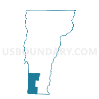
Bennington District 2, Bennington County, Vermont
About
Outline

Summary
| Unique Area Identifier | 680723 |
| Name | Bennington District 2 |
| County | Bennington County |
| State | Vermont |
| Area (square miles) | 8.67 |
| Land Area (square miles) | 8.63 |
| Water Area (square miles) | 0.04 |
| % of Land Area | 99.59 |
| % of Water Area | 0.41 |
| Latitude of the Internal Point | 42.85225750 |
| Longtitude of the Internal Point | -73.18174540 |
Maps


Graphs
Select a template below for downloading or customizing gragh for Bennington District 2, Bennington County, Vermont


Neighbors
Neighoring Voting District (by Name) Neighboring Voting District on the Map
- Bennington District 1, Bennington County, VT
- Pownal Voting District, Bennington County, VT
- Woodford Voting District, Bennington County, VT
Top 10 Neighboring County Subdivision (by Population) Neighboring County Subdivision on the Map
- Bennington town, Bennington County, VT (15,764)
- Pownal town, Bennington County, VT (3,527)
- Woodford town, Bennington County, VT (424)
Top 10 Neighboring Place (by Population) Neighboring Place on the Map
Top 10 Neighboring Elementary School District (by Population) Neighboring Elementary School District on the Map
- Bennington Incorporated School District, VT (14,121)
- Pownal School District, VT (3,527)
- Woodford School District, VT (424)
Top 10 Neighboring Secondary School District (by Population) Neighboring Secondary School District on the Map
Top 10 Neighboring State Legislative District Lower Chamber (by Population) Neighboring State Legislative District Lower Chamber on the Map
- Bennington-2-1 State House District, VT (7,997)
- Bennington-2-2 State House District, VT (7,767)
- Bennington-1 State House District, VT (3,951)
Top 10 Neighboring State Legislative District Upper Chamber (by Population) Neighboring State Legislative District Upper Chamber on the Map
Top 10 Neighboring 111th Congressional District (by Population) Neighboring 111th Congressional District on the Map
Top 10 Neighboring Census Tract (by Population) Neighboring Census Tract on the Map
- Census Tract 9712, Bennington County, VT (5,073)
- Census Tract 9711, Bennington County, VT (4,727)
- Census Tract 9710, Bennington County, VT (3,700)
- Census Tract 9713, Bennington County, VT (3,527)
- Census Tract 9706, Bennington County, VT (3,084)
- Census Tract 9709, Bennington County, VT (2,264)